Today, July 24 – 2020, there is a possible hurricane developing. Originating in the Atlantic basin, moving in the direction of the Caribbean sea. What exactly is the difference between a hurricane, typhoon or cyclone? The quick answer is NOTHING! They are just different names for the same type of storm. Depending on where the storm in the world occurs, all three names are used to describe large rotating storm systems that develop over warm tropical waters.
The weakest tropical cyclones are called tropical depressions. If a depression intensifies such that its maximum sustained winds reach 33 knots, the tropical cyclone becomes a tropical storm. Once a tropical cyclone reaches maximum sustained winds of 64 knots or higher, it is then classified as a hurricane, typhoon, or tropical cyclone, depending upon where the storm originates in the world.
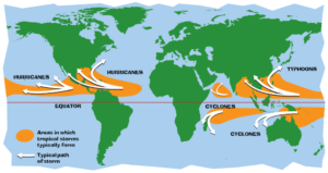
In the North Atlantic, central North Pacific and the eastern North Pacific, the term hurricane is used. The same type of disturbance in the Northwest Pacific is called a typhoon. Meanwhile, in the South Pacific and the Indian Ocean, the generic term tropical cyclone is used, regardless of the strength of the wind associated with the weather system. The ingredients for tropical cyclones include a pre-existing weather disturbance, warm tropical oceans, moisture, and relatively light winds. If the right conditions persist long enough, they can combine to produce the violent winds, large waves, torrential rains, and floods we associate with this phenomenon. In the Northern hemisphere, the hurricane season officially runs from June 1 to November 30. Ninety-seven percent of tropical cyclone activity occurs during this time period. However, there is nothing magical about these dates. Hurricanes can and do occur outside of this six month period.
Categories
Tropical cyclones are categorized according to the speed of sustained winds.
Tropical Depression – 33 knots or less
Tropical Storm – 34 to 64 knots
Hurricane (Saffir-Simpson scale)
Category 1 – 65 to 82 knots
Category 2 – 83 to 95 knots
Category 3 – 96 to 113 knots
Category 4 – 114 to 135 knots
Category 5 – 135 knots or higher
Parts of a Hurricane
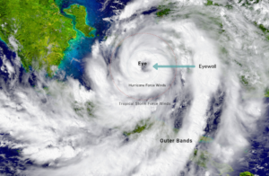
Eye – At the centre of the hurricane is the eye. The eye is an area of very low air pressure. There are generally no clouds in the eye and the wind is calm. Don’t let this fool you, however, the most dangerous part of the storm is at the edge of the eye called the eyewall.
Eyewall – Around the outside of the eye is a wall made up of very heavy clouds. This is the most dangerous part of the hurricane and where the highest wind speeds occur. The winds at the eyewall can reach speeds of 135 knots.
Rainbands – Hurricanes have large spiral bands of rain called rainbands. These bands can drop huge amounts of rainfall causing flooding when the hurricane hits land.
Diameter – Hurricanes can become huge storms. The diameter of the hurricane is measured from one side to the other. Hurricanes can span a diameter of over 1000 kilometres.
Height – The storm clouds that power hurricanes can become very tall. A powerful hurricane can reach 15 kilometres into the atmosphere.
A Hurricanes Biggest Threat: Storm Surge
A storm surge is an offshore rise of water associated with a low-pressure weather system, typically hurricanes. Storm surges are caused primarily by high winds pushing on the ocean’s surface. The wind causes the water to pile up higher than the ordinary sea level. In areas where there is a significant difference between low tide and high tide, storm surges are particularly damaging when they occur at the time of high tide. In these cases, this increases the difficulty of predicting the magnitude of a storm surge since it requires weather forecasts to be accurate to within a few hours. Storm surges can be produced by extra tropical cyclones, such as the Night of the Big Wind of 1839 and the Storm of the Century (1993), but the most extreme storm surge events typically occur as a result of tropical cyclones. Factors that determine the surge heights for landfalling tropical cyclones include the speed, intensity, size of the radius of maximum winds (RMW), radius of the wind fields, angle of the track relative to the coastline, the physical characteristics of the coastline and the bathymetry of the water offshore.
Did you know that:
Tropical cyclones above the equator spin counterclockwise, while those below it spin clockwise. This is not a difference in storms, but rather a result of the Coriolis effect, a force in physics causing our position on earth to shape our perspective.
If a storm forms in one place and crosses over the International Date Line, it will change names. For instance, in 2014 Hurricane Genevieve formed in the eastern Pacific but became Super Typhoon Genevieve as it moved west and crossed the International Date Line.
The letters Q, U, X, Y, and Z are not used for the first letter when naming hurricanes.
The names are alternated between boy and girl names.
Weather forecasters draw a cone showing where they think the hurricane is most likely to travel.
GONZALO, the first possible hurricane of the 2020 season.
Tropical Storm Gonzalo, trying to become the first hurricane of the 2020 Atlantic hurricane season, is headed to the Windward Islands this weekend, but is expected to wither in the Caribbean Sea next week. Gonzalo’s centre is located several hundred miles east of the southern Windward Islands, moving west. Gonzalo has been battling dry air, which is plentiful to its north and west. Its circulation ingested some of this dry air early Thursday morning, putting the brakes on its intensification, at the time. While its thunderstorms are more clustered near the centre now, the convection remains rather dishevelled at the moment. Wind shear is not an overwhelming inhibiting factor for Gonzalo right now, though the latest analysis suggests some modest shear may be affecting Gonzalo.
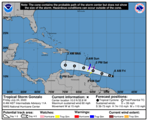 Gonzalo is expected to encounter some modest wind shear in the eastern Caribbean Sea early next week, complicating that part of the forecast. However, there is an ample supply of warm, deep ocean water ahead of Gonzalo, generally warmer than average for this time of year. Furthermore, Gonzalo is a tiny storm. Small storms like this can intensify quickly in the right conditions, but they can also succumb to unfavourable conditions more quickly than a larger storm. In other words, they can strengthen and weaken much more and at a faster rate than expected. So, the range of outcomes for the intensity forecast is higher than a typical forecast. Gonzalo could become a hurricane and sweep through the Windward Islands, or continue struggling as a tropical storm until then. Once in the Caribbean Sea, Gonzalo is expected to encounter a more hostile environment of dry, stable air that would suppress thunderstorms, as well as the aforementioned wind shear. Fortunately, the track forecast is a bit more straightforward. They expect a general west-northwest track into the Windward Islands by Saturday, then into the eastern Caribbean Sea by Sunday. Gonzalo is the earliest seventh named tropical storm on record to form in the Atlantic basin. The previous record was held by Tropical Storm Gert, which developed on July 24, 2005.
This video describes how and where hurricanes are formed, their structure, and how they cause damage.
Source: https://www.ibiblio.org/openvideo/video/cmu/UGS13.mpg
Leave A Comment